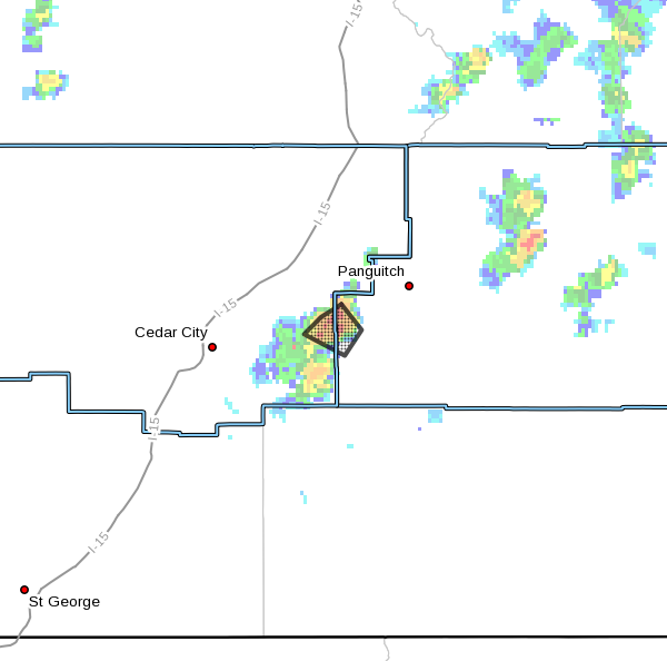
ST. GEORGE — Flash flooding is expected Saturday in portions of Iron and Garfield counties near Panguitch Lake and state Route 143.
The National Weather Service in Salt Lake City has issued a flash Flood Warning for the area in effect until 4:30 p.m. MDT.
At 1:33 p.m. MDT, Doppler radar indicated that heavy rainfall has been falling over the Panguitch Creek portion of the Brian Head fire burn scar. Radar estimates indicate that 1 inch of rain has fallen on the burn scar in a matter of hours.
The National Weather Service says it expects that the amount of rainfall will result in flash flooding and a debris flow through the Panguitch Creek drainage. SR-143 is expected to receive debris, as well as locations along Panguitch Creek downstream to Panguitch Lake.
People in these areas should take action to ensure their safety.
Precautions
Remain alert for flooding even in locations not receiving rain. Dry washes, streams and rivers can become raging killer currents in a matter of minutes, even from distant rainfall.
The National Oceanic and Atmospheric Association and the National Weather Service offer the following safety rules for flash flooding:
- When a flash flood warning is issued for your area or the moment you first realize that a flash flood is imminent, act quickly to save yourself. You may have only seconds.
- Most flood deaths occur in automobiles. Do not drive your vehicle into areas where the water covers the roadway. Flood waters are usually deeper than they appear. The road bed may not be intact under the water. Just 1 foot of flowing water is powerful enough to sweep vehicles off the road. If the vehicle stalls, abandon it immediately and seek higher ground. Rapidly rising water may engulf the vehicle and its occupants and sweep them away.
- Do not hike rivers and especially slot canyons while flash flood warnings are in place.
- Do not hike alone and always tell someone where you and your buddy and others are going.
- Get out of areas subject to flooding, including dips, low spots, canyons and washes.
- Avoid already flooded and high-velocity flow areas. Do not try to cross a flowing stream on foot where water is above your knees.
- Be especially cautious at night when it is harder to recognize flood dangers.
- Do not camp or park your vehicle along streams and washes, particularly during threatening conditions.
During any flood emergency, stay tuned to official weather reports via radio, television and social media. Cell phone users can also sign up to receive weather alerts as text messages. You can also follow St. George News and Cedar City News for weather alerts and updates relevant to Southern Utah.
Email: [email protected]
Twitter: @STGnews
Copyright St. George News, SaintGeorgeUtah.com LLC, 2018, all rights reserved.